 due to the almost
complete absence of surface water and the fragile vegetation, very few people
lived in this area of undulating plains of dry Kalahari bush savannah.
due to the almost
complete absence of surface water and the fragile vegetation, very few people
lived in this area of undulating plains of dry Kalahari bush savannah.|
Khutse
Game Reserve Ghanzi |
The 2,500 square kilometre Khutse Game Reserve
in Botswana was opened
in 1971, on Bakwena tribal land. Prior to this date,
due to the almost
complete absence of surface water and the fragile vegetation, very few people
lived in this area of undulating plains of dry Kalahari bush savannah.
Those
who did subsisted by gathering wild foods, undertaking limited hunting and
keeping small stock. Wildlife was therefore considered to be a good
alternative form of land use.
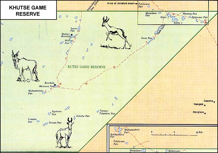
The extensive mineralised pan system within Khutse provides an important
habitat for wildlife attracting herbivores to graze on the grasses of the
pans, drink the mineralised water- during the rainy season and to lick salt
during the dry season.
These herbivores in turn attract predators, such as
lion, cheetah and leopard. Boreholes have been established at certain points
within the reserve in order to encourage wildlife to stay within the area
throughout the year.
Whilst the visitor to Khutse should not expect to see or meet up with large
concentrations of game, giraffe, gemsbok, red hartebeest, eland, kudu,
wildebeest, springbok, steenbok, grey duiker, lion, leopard, cheetah, brown
hyena, black-backed jackal, bat-eared fox and wild dog can be seen within
Khutse, as well as many other smaller mammals. A wide range of birdlife from
ostrich and kori bustard down to the LBJs (little brown jobs) will keep bird
enthusiasts well occupied.
How to get there
The route from Botswana's capital Gaborone to the Khutse Game Reserve covers
some 210 kilometres of varying road conditions taking some four hours of
driving time. The first 50-kilometre section is along a good national road to
Molepolole, where a turn to the right is taken following the directional signs
to Letlhakeng. A further 61 kilometres of good tar road brings the traveller
to the village of Letlhakeng, where the feature of a traffic circle brings an
end to the tar. At this circle a green sign indicating the direction to Khutse
is a most welcome sight as the variety of tracks is confusing to the
uninitiated. Letlhakeng has a small filling station.
Proceeding along a sand road after Letlhakeng soon illustrates to the
traveller why only 4x4 vehicles are recommended, as the sand is loose and
deeply rutted, particularly during the dry season from about April to the time
when the rains break usually in November. Some 25 kilometres from Letlhakeng
is striking Khudumelapye, where an abundance of fine trees gives this village
the appearance of being an oasis. Here large pools of sweet water accumulate
following heavy rains and large numbers of livestock congregate. This is very
much cattle country.
A further 36 kilometres of sandy road brings the traveller to the last large
settlement before reaching Khutse. This village is called Salajwe and some
basic supplies and drinks may be obtained there. The traveller will notice
that it is not always easy to find the way through the villages, as tracks
seem to lead in all directions. However, the green Khutse signs are there as a
guide. The remainder of the journey has fewer features, although there are
small settlements away from the road.
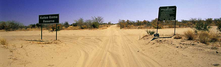
Eventually a sign advises the weary traveller that the boundary of Khutse Game
Reserve has at last been reached. A short distance later the National flag can
be seen flying above the trees, and the Wildlife Camp, which incorporates the
tourist reception office, is finally reached. Here visitors are required to
check in and pay the fees for their stay.
Camping facilities
There are no tourist lodges, no chalets nor rest camps in Khutse. Nor are
there any shops or fuel supplies. Khutse is a protected area where development
has been kept to a minimum and where the wilderness atmosphere has been
carefully preserved. There are areas that have been designated as campsites,
some of which have pit latrines but no other form of development. Although
Botswana's central and southern parks and reserves are not as well known as
their northern sisters, visitors who are devoted to the wilderness have come
from places as far afield as Spain and the United States to enjoy the
wonderful sense of isolation and timelessness these areas have to offer.
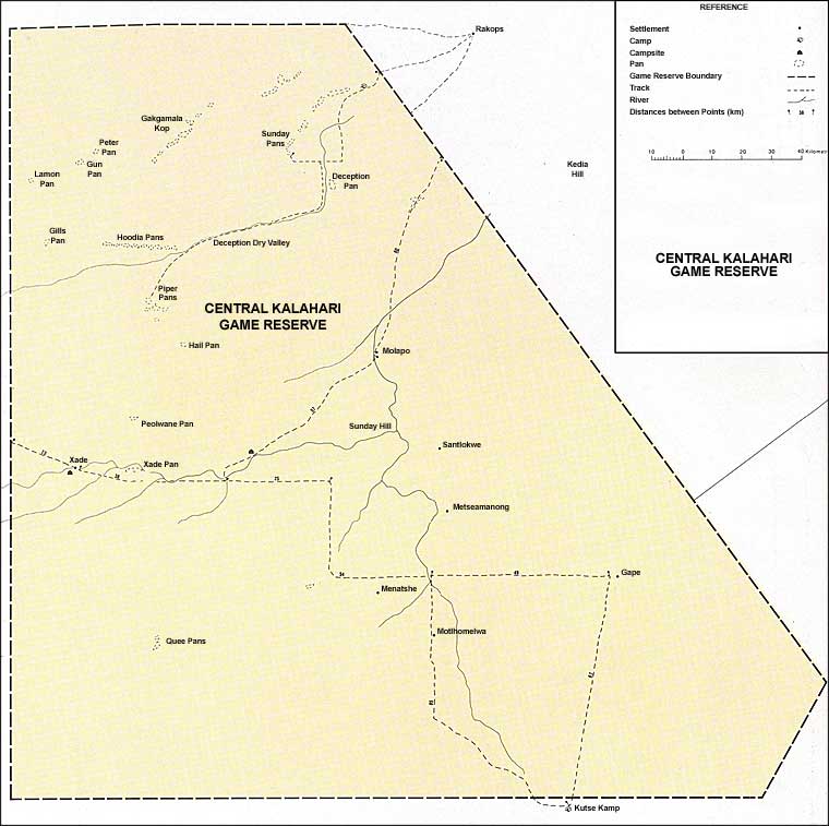
The main concentration of campsites is grouped in an area between Khutse I and
Khutse II Pans, whilst more isolated individual camps are to be found at
Moreswe Pan in the south-western area of the reserve. Further isolated sites,
named Mahurushele, Sekusuwe and Khankhe, are actually situated in the
adjoining Central Kalahari Game Reserve but administered by Khutse. Visitors
to Khutse should be completely self-contained with all their requirements
including drinking water.
Water for purposes other than drinking can be obtained from the Wildlife Camp.
All litter should either be totally removed from the reserve or deposited at
the Wildlife Camp. The basic rules to be observed when in the reserve are to
drive only on the tracks indicated on the map that is obtained on arrival; to
camp only at the designated campsites which are clearly indicated; to ensure
that no grass fires are caused, nor litter left, nor other visitors disturbed
- in other words consideration for others and for the environment should be of
paramount concern.
When travelling between Molose Waterhole and Moreswe Pan, first time visitors
will be interested to come across a sign in what appears to be the middle of
nowhere, proclaiming that this point intersects the Tropic of Capricorn. There
cannot be many visitors who have not stopped there to take a photographic
record of this.
How to get to
Khutse Game Reserve (GPS Coordinates)
Mahurushele and khanke campground in the Khutse Game Reserve GPS coordinates:
(1)23°16’58.74”S24 °23’16.70”E
(2)23°17’39.01”S24 °23’17.68”E
(3)23 °16’59.32”S24 °24’0.68”E
(4)23 °17’39.32”S24 °24’4.61”E at Mahurushele
(1)23°13’42.50”S24 °20’48.34”E
(2)23 °13’28.54”S24 °21’15.07”E
(3)23 °13’36.15”S24 °21’20.92”E
(4)23°13’49.64”S24 °20’54.27”E at Khankhe
Measuring: 1.6 square kilometers and Mahurushele and 332 000 square meters at
Khankhe. Measuring: 9.88 square kilometers at Molose
and 4.2 square kilometers at Moreswe. At Moloswe and Moreswe Campgrounds in
the Khutse Game Reserve GPS Coordinates:
(1)23 °24’35.78”S24 °9’28.69”E
(2)23 °22’34.85”S24 °10’44.08”E
(3)23 °23’20.75”S24 °11’55.70”E
(4)23 °25’5.35”S24 °10’14.21”E at Moloswe
(1)23 °33’51.07”S 24 °5’25.29”E
(2) 23 °33’9.12”S 24 °6’26.33”E
(3)23 °33’57.89”S 24 °7’17.35”E
(4)23 °c34’32.22”S 24 °6’5.95”E at Moreswe
Facebook groups:
NAMIBIA: https://www.facebook.com/groups/namibia.namibia
BOTSWANA: https://www.facebook.com/groups/botswana1
DRONESBERG: https://www.facebook.com/dronesberg
Contact & reservations:
E-mail:
info@namibweb.com
| Related | Maps | Accommodation in the area | Activities in the area | ||||
| Hotels | Pensions | B&Bs | Lodges | Camping & others | |||
| Accommodation Botswana | Map | The Kalahari Manor | Thakadu Bush Camp | - | Deception Valley Lodge | Khutse camp ground | - |
| Camping sites in national parks | Map CKGR | Edo's Camp | - | - | Grasslands Bushman Lodge | Khawa Safari Lodge | - |
| Ghanzi | - | Kalahari Arms Hotel | - | - | Motswiri Lodge | Thakadu Bush Camp | - |
| Central Kalahari Game Reserve | - | Khutse Kalahari Lodge | - | - | Tautona Lodge | - | - |
![]()
![]()
![]()
Page created and serviced by
![]()
www.namibweb.com
Copyright © 1998-2025 namibweb.com - The online guide to
Botswana
All rights reserved |
JOIN
|
VIDEO PORTFOLIO
|
VIDEO/PHOTO COLLECTION
Telegram
| YouTube |
Blog
Page is sponsored by ETS &
Exploring Namibia TV
Disclaimer: no matter how often this page is updated and its accuracy is checked,
www.namibweb.com and ETS
will not be held
responsible for any change in opinion, information, facilities, services,
conditions, etc. offered by
establishment/operator/service/information provider or any third party
Description & images: Copyright © www.namibweb.com