The Kwando
River
Rivers of Namibia
The Cuando River
 (usually spelled Kwando in Namibia) is a river in
south-central Africa flowing through Angola and Namibia's Caprivi Strip,
into the Linyanti Swamp on the northern border of Botswana.
Downstream Linyanti Swamp
the river is called the Linyanti River, and further east the Chobe River,
before it flows into the Zambezi River.
(usually spelled Kwando in Namibia) is a river in
south-central Africa flowing through Angola and Namibia's Caprivi Strip,
into the Linyanti Swamp on the northern border of Botswana.
Downstream Linyanti Swamp
the river is called the Linyanti River, and further east the Chobe River,
before it flows into the Zambezi River.
Course of the river
The Cuando rises in the central plateau of Angola on the slopes of Mount
Tembo, thence flowing southeast along the Zambian border. Along this reach
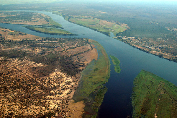
it flows in a maze of channels in a swampy corridor 5–10 km wide. As with
all rivers in south-central Africa its flow varies enormously between the
rainy season when it floods and may be several kilometers wide, and the dry
season when it may disappear into marshes.
The Cuando continues in its marshy channel across the neck of the Caprivi
Strip of Namibia and then forms the border between Namibia and Botswana as
it continues southeast. Some 10,000 years ago, the Cuando merged with the
Okavango River and they flowed south to Lake Makgadikgadi (which is a
seasonal wetland in current times), but the land in that area was uplifted.
As a consequence the Cuando now meets slightly higher ground and breaks up
into many channels and swamps (called the Linyanti Swamp) dotted with
alluvial islands, nearly disappearing into the Kalahari sands like the
Okavango. But instead it has diverted east and has been captured by the
Zambezi. The flow turns sharply east, still forming the border with
Botswana. In the dry season there are few open channels through the swamps
and marshes. Beginning at this point it is known as the Linyanti, and after
it flows through a seasonal lake, Lake Liambesi, it is called the Chobe. The
river then flows into the Zambezi just above the Kazungula Ferry.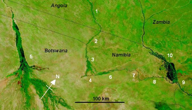
In years when the Okavango experiences a good flood some of the water
escapes east along the normally dry channel of the Magwekwana River into the
Linyanti Swamp, thus entering the Zambezi basin. Otherwise the Okavango
basin has no outlet.
On the north side of the Chobe River are the Caprivi Swamps, on the edge of
which is the ruined capital of the Kololo people who conquered Barotseland
in the 19th Century.
So much of the water of the Cuando, Linyanti and Chobe is lost to
evaporation in the various swamps that its contribution to the flow of the
Zambezi is very small except in occasional years when it floods excessively.
Wildlife
The Cuando system is noted for its wildlife and for most of its length the
land either side is protected as game reserves or wildlife management areas.
Some of these suffered poaching during wars and conflict in Namibia and
Angola, but with peace restored in those countries they have the chance of
returning to their former state.
The national parks through which it passes or on which it borders are:
Coutada Publica do Luiana (Angola)
Sioma Ngwezi National Park (Zambia)
West Caprivi Game Park (Namibia)
Mudumu National
Park (Namibia)
Mamili National
Park (Namibia)
Chobe National Park (Botswana)
Contact & information:
E-mail:
info@namibweb.com
Reservations are only accepted in writing: by fax or via e-mail.
Final availability confirmation: in writing: by fax or via e-mail.
Terms & conditions,
Payment options and
Cancellation policy


Page created and serviced by

www.namibweb.com
Copyright © 1998-2025
namibweb.com - The online guide
to Namibia
All rights reserved |
JOIN
|
VIDEO PORTFOLIO
|
VIDEO/PHOTO COLLECTION
Telegram
| YouTube |
Blog
Page is sponsored by ETS &
Exploring Namibia TV
Disclaimer: no matter how often this page is updated and its accuracy is checked,
www.namibweb.com and ETS
will not be held
responsible for any change in opinion, information, facilities, services,
conditions, etc. offered by
establishment/operator/service/information provider or any third party
Brian McMorrow NASA