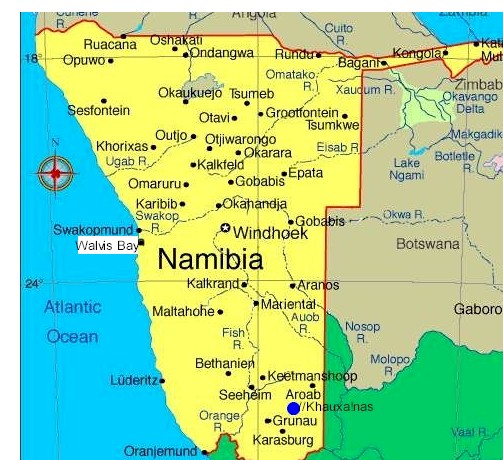
The Karas Region is
the southernmost region of Namibia. The name assigned to the region reflects
the prominence of the Karas mountain range in its southern part. The Karas
region is considered as a natural organic administrative and economic unit
and includes the magisterial districts of Keetmanshoop, Karasburg, Bethanie
and
Luderitz.
Karas' western border is the shores of the Atlantic Ocean. Its location in
Namibia's south means that it shares a long border in the south and east
with the Northern Cape Province of South Africa. Domestically, it borders
only the Hardap Region, to the north.
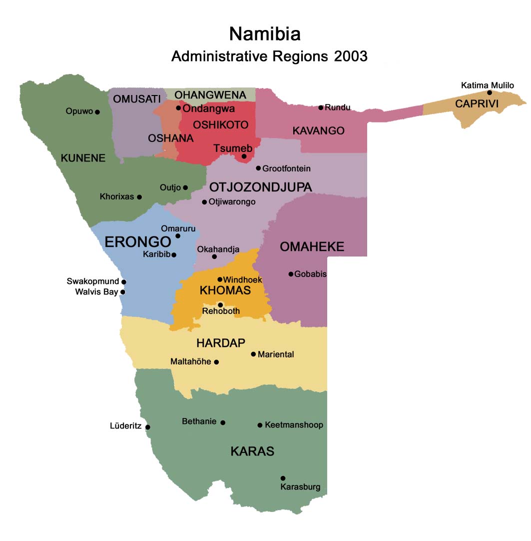
Karas is subdivided into six electoral constituencies:
Berseba
Karasburg
Keetmanshoop Rural
Keetmanshoop Urban
Lüderitz
Oranjemund
Politics
The Governor of Karas Region is Bernardus Swartbooi. In the 2004
presidential election, the region supported SWAPO's Hifikepunye Pohamba with
65% of the votes. No other candidate received more than 10%.
Economy
The region is a predominantly small stock farming area, consisting mostly of
animals such as sheep or goats. Game farming and irrigation farming along
the Naute Dam and the Orange River have gained significantly in importance.
A further characteristic of the Region is the harbour town of
Luderitz and
its fishing and boat building industry, the diamond areas along the coast,
both on and off shore, with Oranjemund as the main centre, mining
enterprises in the southern part of Namibia (Klein Karas area, Rosh Pinah),
the Kudu Gas field in the Atlantic Ocean near Lüderitz and small-scale
industries in Lüderitz and Keetmanshoop.
The Hot Water Springs at Ai-Ais, and in future probably also the Hot Water
Springs in Warmbad, the Kokerboom forest near Keetmanshoop, the Fish River
Canyon which is the second largest in the world, the Brukaros Mountain (a
former volcano) near Berseba, the coastal town Lüderitz and several guest
and game farms gave become important tourist attractions. The tourism
industry has the potential for further expansion.
The economic growth potential of the area is considerable but needs an
intensive general development policy. It is a profitable tax-generating
area, which predominantly comes from diamond mining for the central
government.
The main railway line and two main trunk roads give access to South Africa.
Keetmanshoop is considered as the capital of the south and has direct air,
railway and road links with Windhoek. Its airport is of international
standard and suitable for international air traffic. The airfield at
Kolmanskop near Lüderitz is regularly visited by Air Namibia on its flights
to Cape Town and Windhoek. Well developed landing facilities also exist at
Oranjemund.
The region comprises six constituencies: Keetmanshoop Urban, Berseba,
Lüderitz, Oranjemund, Karasburg, and Keetmanshoop Rural.
Investment rewards for all Potential for the tourism investor abounds in a
country with so many as yet unexploited sites. Hospitality venues, resorts,
tour operations and adventure excursions, game farming and hunting, local
and ethnic craft manufacture are but a few of many opportunities open to the
investor. These enterprises have the power to absorb local workers and
improve labour skills – crucial where subsistence-type economic activity is
still evident in rural areas and employment opportunities limited. Many
incentives to businesses that actively integrate local peoples into tourism
and related service industries are available from government.
Demographics
According to the Namibia 2001 Population and Housing Census, Hardap had a
population of 69,329 (32,346 females and 36,976 males or 114 males for every
100 females) growing at an annual rate of 1.3%. The fertility rate was 3.1
children per woman. 54% lived in urban areas while 46% lived in rural areas,
and with an area of 161,215km2, the population density was 0.4 persons per
km2. By age, 11% of the population was under 5 years old, 20% between 5-14
years, 63% between 15-59 years, and 6% 60 years and older. The population
was divided into 15,481 households, with an average size of 4.1 persons. 35%
of households had a female head of house, while 65% had a male. For those 15
years and older, 69% had never married, 20% married with certificate, 2%
married traditionally, 5% married consentually, 1% were divorced or
separated, and 2% were widowed.
The most commonly spoken languages at home were Afrikaans (40% of
households), Nama/Damara (26%) and Oshiwambo (23%). For those 15 years and
older, the literacy rate was 87%. In terms of education, 52% of girls and
48% of boys between the ages of 6-15 were attending school, and of those 15
years and older, 77% had left school, 7% were currently at school, and 7%
had never attended.
The employment rate for the labor force (67% of those 15+) was 71% employed
and 29% unemployed. For those 15 years old or older and not in the labor
force (24%), 28% were students, 40% homemakers, and 32% retired or unable to
work.
Among households, 94% had safe water, 26% no toilet facility, 50%
electricity for lighting, 81% access to radio, and 35% had wood or charcoal
for cooking. In terms of households' main sources of income, 7% derived it
from farming, 69% from wages and salaries, 6% cash remittances, 5% from
business or non-farming, and 10% from pension.
For every 1,000 live births there were 37 female infant deaths and 56 male.
The life expectancy at birth was 61 years for females and 54 for males.
Among children younger than 15, 4% had lost a mother, 6% a father, and 1%
were orphaned by both parents. Three percent of the entire population had a
disability, of which 22% were deaf, 29% blind, 10% had a speech disability,
13% hand disability, 27% leg disability, and 7% mental disability.
Country: Namibia
Capital:
Keetmanshoop
Government:
• Governor Dawid Boois
Area:
• Total 161,487 km2 (62,350.5 sq mi)
Population (2001):
• Total: 69,985
• Density: 0.4/km2 (1.1/sq mi)
Time zone: South African Standard Time: UTC+1
Facebook:
NAMIBIA: https://www.facebook.com/groups/namibia.namibia
TRAVEL NAMIBIA: https://www.facebook.com/groups/travelnamibia
KEETMANSHOOP: https://www.facebook.com/groups/keetmanshoop.namibia
| Related | Maps | Accommodation in the area | Activities in the area | ||||
| Hotels | Pensions | B&Bs | Lodges | Camping & others | |||
| Luderitz | General map | Bahnhof Hotel | - | - | Klein Aus Vista | Namtib Biosphere Reserve | Huib Plateau tours |
| Rosh Pinah | Regions | Bethanie Hotel | - | - | - | Klein Aus Vista | - |
| Photo galleries | - | - | - | - | - | - | - |
| Regions of Namibia | - | - | - | - | - | - | - |
Contact & information:
E-mail:
info@namibweb.com
Terms & conditions, Payment options and Cancellation policy
![]()
![]()
![]()
Page created and serviced by
![]()
www.namibweb.com
Copyright © 1998-2025
namibweb.com - The online guide
to Namibia
All rights reserved |
JOIN
|
VIDEO PORTFOLIO
|
VIDEO/PHOTO COLLECTION
Telegram
| YouTube |
Blog
Page is sponsored by ETS &
Exploring Namibia TV
Disclaimer: no matter how often this page is updated and its accuracy is checked,
www.namibweb.com and ETS
will not be held
responsible for any change in opinion, information, facilities, services,
conditions, etc. offered by
establishment/operator/service/information provider or any third party