Coastways Safaris
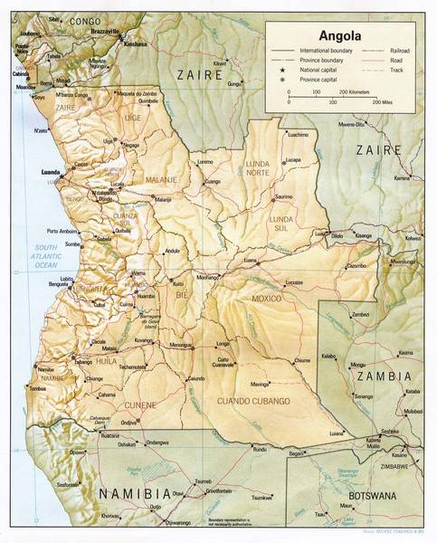
Angola
Adventure: various roads in Angola has only recently been restored opening up
new exciting areas for tourism in Angola.
Angola is a giant jigsaw puzzle of different climates, landscapes, cultures and
colors. From mountains to vast open plains, wide white beaches to thick tropical
rainforest, Angola has it all, as if each of its eighteen provinces were a
different country. Lubango has a mild temperate climate, Luanda is hot and dry,
while Cabinda is steamy and tropical. Much of the landscape is dramatic, with
plunging waterfalls, bizarre rock formations and deep gorges. Leba mountain in
Huila province rises out of Tundavala gorge to give stunning views of the vast
Namibe desert. On this trip we will be amongst the first to explore this
contrasting area of green forests, a maize of rivers changing to a more dry area
with huge baobab forests ending up at the Atlantic with its beautiful beaches.
The route will take us through various of Angolaĺs southern provinces ľ
ôtraditionallyö only the most south-westerly areas (Namibe, Huila en Cunene)
were considered Ĺsafeĺ and trips were conducted mainly in this area. Demining
and re-construction of roads, infrastructure etc makes it possible to venture
safely deeper into Angola so far as the Kongo river.
THE PROVINCE OF
KUANDO KUBANGO
Kuando Kubango is the second
largest province in Angola, after Moxico. It borders with the Republic of Zambia
to the east and the Republic of Namibia to the south. The city of Menongue was
founded on the banks of the River Kuebe and due to the tremendous efforts of its
inhabitants, offers the visitor an architectural beauty which is second to none,
apart from breathtaking landscapes which can be seen. The population (14,999)
lives mainly from agriculture. It was one of the worst affected provinces during
the war, which lasted for 20 years.
THE PROVINCE OF BIE
Bie is a vast plain with an
area of 70,314 km2, in the shape of a heart, in the geographical centre of
Angola, in the municipality of Kamacupa, where the colonial power set up a
statue of Christ the King. The main economic activity is agriculture. The
average temperature is 21░C. The climate is tropical, with two seasons: the
rainy season and the dewy season. The dewy season is cold, with moderate
temperatures between May and September, while the rainy season is longer,
normally beginning at the end of September and finishing at the beginning of
May. The rain is usually associated with thunderstorms.
THE PROVINCE OF HUAMBO
The capital city of this
province, which has an area of 34,270 km2, has the same name. The area has an
excellent climate, geographical position favourable for agriculture and a good
hydro graphic grid, friendly population and network of rivers for fishing and
swimming. General Jose Mendes Norton de Matos, The Governor, founded the plain
city of Huambo on 8th August, 1912.
In 1928,
the
engineer Antonio Vicente Ferreira, baptized the city of Huambo with the name
Nova Lisboa (New Lisbon) and prepared it to be the capital of Angola. However
only the name of the city was changed because of the various schools of opinion
opposed to this city becoming the capital of the country, because of Luandaĺs
more favourable position, at sea. Huambo became the site of a brutal battle
during the bloody civil war between the government and UNITA from independence
until the death of rebel leader Jonas Savimbi. The city was besieged,
extensively damaged, and its civilians fled the city.
The Huambo province was the heartland of Angolaĺs coffee production during the
colonial era. The province was divided into vast rocas (plantations) by the
Portuguese who found the soil and climate ideal for Robusta coffee. In the years
leading up to independence, Angola was exporting 4000,000 tons of coffee per
year (1972-3 figures), and the country was the worldĺs main producer of robusta
coffee. But war and mismanagement led to the collapse of coffee production after
independence, with exports sinking to about one tenth of their former volume.
THE PROVINCE OF BENGUELA
Famous for its beaches,
Benguela is situated on the coast in the centre of Angola. It has a tremendous
geographical diversity and owes its name to
the
Benguela cold stream which runs from Antarctica. Its location makes Benguela an
important connection between the country's different regions. Its relief is
varied, dividing the province into three distinctive geographical areas: the
coastline, where the altitude goes from 0 to 500 metres, the centre (500 to 1200
m.) and east, (over 1500 m. average altitude) which is connected to the high
plains of the interior of Angola. Annual rainfall levels range from 600 mm. in
the north to 100 mm. in the south, making a contrast between the regions, from
the fertile Vale do Cavaco to the semi-desert terrain of the southern part of
the province, which blends into the characteristic landscape of the province of
Namibe, which it borders onto. The first landing of Portuguese took place early
as 1600ĺs. They were attracted by an apparent animal richness. After that the
legends of the rich silver and copper mines of the region resulted in the
foundation of S. Filipe de Benguela that would become the basis of penetration
in the island. Lobito was founded in 1843 by the Portuguese. The longest railway
line in Angola, which crosses the country to its borders with Zambia and DR
Congo, departs from its second city, Lobito, which has a deep water port. The
completion of the railroad from Benguela in 1929 made Lobito an important
commercial centre and Angolaĺs chief port, but it declined in the 1970ĺs due to
damage of port facilities during the War of Independence from Portugal. The need
for a harbour and the wonderful conditions gave form to Lobito.
THE PROVINCE OF NAMIBE
This is the greatest fishing
centre of Angola, the province of Namibe is named after the desert which
occupies the
majority of its area. It is famous around the world for a rare plant which is
found here, the Welwitschia Mirabilis. Its capital is in an enormous bay which
deadens the fury of the Atlantic waves, creating some of the finest beaches in
the world. This region was firstly touched in 1485 by a European, Diogo
Cao. It was named of Mocamedes and was the first district to be created in the
South of Angola. In 1840. The organised exploitation of the regionĺs richness
began in 1849 with the arrival of the first settlers coming from Brazil.
THE PROVINCE OF MALANJE
Malanje is the capital city
of Malanje Province in Angola. The main tourist attraction, the Calandula
waterfalls are 105 metres high and their great width makes a breathtaking sight. Pedras Negras de Pungo Andongo are massive black rocks. The greatest dam in the
country is in Malanje, in the municipality of Capanda. The climate is mainly
humid, with average temperatures between 20 and 24░C and rainfall 900 mm to 130
mm in the rainy season (October to April).
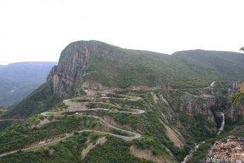
THE PROVINCE OF HUILA
Lubango is the capital city
of the province of Huila, which has an area or 75, 002 km2. Initially, with the
Portuguese colonization, Huila was included in the territory of Benguela and by
a decree law passed in April 1849 and integrated in the District of Mocamedes
(now called Namibe). The municipality of Humpata has great tourist potential. It
was where the first colonies were set up, due to the natural beauty of the area.
This region was discovered by the öDorsland Trekkersö on 4th January, 1881. It
was declared a council (municipality) on 17th January, 1883. The Madeira people
appeared a bit later in January 1885. The colony of Sa da Bandeira was
established.
The great number of waterfalls forms the landscape that surrounds Lubango. But
the most photographed places are perhaps presently, the fissure of Tunda-Vala
and the Leba Hill with its incredible asphalt spiral (Leba pass)
Itinerary
Everybody assembles
at Rundu from were will depart for Angola (Katwitwi) the next day. Last minute
shopping, stocking up on fuel to cover a distance of 900 km (worst case
scenario).
Days 1- 3: Depart early morning to be at the border post at 07H00. After
crossing the border the road leads northwards along the western banks of the
Kavango river towards Menonque (550km ľ although fuel could be available at
Menonque it can not be guaranteed). From Menonque the planned destination will
be Chinguar were we will camp at the origin of the Okavango river. It is quite a
sight looking at the humble beginning of a Ĺmighty riverĺ which ends in Botswana
creating the renowned Okavango Delta.
Days 4-8: We continue the journey northwards towards Calundula. The the
Calundula Falls is an awe-inspiring sight and said to be Africa`s third largest
waterfall. The 105 meter tall waterfall, is located 85 km from the provincial
capital of Malange. This is the most northern turning point. From here we turn
towards Quibala, Gabela, Sumbe, Lobito and Benquella. During the 5 days we will
travel through ever changing landscapes varying from the fertile highlands ,
tropical forests and coffee plantations in the interior to a semi-desert area
bordering the coastline.
Days 9-12: From Benquella we turn south towards the province of Namibe at a more
leisury pace, visiting some of the remote beaches along the coast. There will be
time for those who want to do some fishing, otherwise we will just enjoy the
beauty and tranquillity of the remote beaches along the coast.
Day 13 -15 We start the return trip heading for Lubango, driving via the
spectacular Leba Pass with its awesome hairpin bends and waterfalls. The road
ascends from the coastal plain to an altitude of over 6 000 feet in just a few
kilometres. From Lubango we turn south via Cahama towards the Ruacana border
post. Depending on progress it may be possible to cross the border into Namibia
already on day 14. After crossing the Cunene you will be back in Namibia and it
is time for sad farewells. Here our ways part.
ANGOLA ADVENTURE
INFORMATION
INOCULATIONS AND MEDICATION
Ľ Yellow fever inoculation is
compulsory and proof of this must be submitted.
Ľ Medication against Malaria
Ľ Cholera inoculation is not compulsory but is recommended.
VISA APPLICATION
Ľ Invitation letter will be
arranged by Uri Adventures. We require full names, passport number and expiry
date 2 months before the departure date.
Ľ Each individual must have a copy of this in their possession when crossing the
border.
COPIES
4 Copies of each of the
following documents.( At least one document must be certified).
Ľ Passport
Ľ Invitation letter
Ľ ID document
Ľ Visa
Ľ Registration certificate of the vehicle
Ľ Police Clearance of vehicle.
Ľ Drivers license
Ľ Authority letter ľ if the vehicle is bought on a hire purchase and if the name
on the registration certificate indicates another personĺs name.
Ľ Invitation letter ľ a copy of this letter must be shown at the border.
INSURANCE
Ľ Medical Aid ľ Please
confirm with your medical aid that it makes provision for emergency care and
ôEvacuationö in Angola.
Ľ Insurance ľ Please confirm with your insurance company that you are covered in
Angola (vehicle and personal effects).
BORDER FEES
Ľ Ĺa ô Cross border feeö,
payable at the border per vehicle: you will be notified on the current amount in
advance.
FUEL
Ľ Angola price R7.00 (Petrol)
and R5.00 (Diesel), but it can change. Please keep in mind that your vehicle
must be able to cover a distance of 1000km before refill. Please make the
necessary provision to ensure that it is possible. Extra cans are in order.
DINNER
Time permitting the group
will have a night out in Angola trying local cuisine.
MONEY EXCHANGE
Ľ All depending on the
current exchange rate:
Ľ 1 USD for 90 KW.
Ľ 1 Rand for 9 KW.
It is recommended that each vehicle can take approximately U$500 to be exchanged
in Angola for Kwanza which is local currency of Angola this can be used at the
markets and to refuel the vehicles. Please note that it is difficult to exchange
the smaller domination U$ notes in Angola please ensure that you take bigger
domination notes such as U$ 20/50/100. Please also make sure that the notes must
all be printed later then 2006 (Larger Head identification).
Essentials
The following items are mandatory for each participation vehicle:
Police Clearance if needed to cross border. (Vehicle)
Passport & Visa
Cross border fees payable at the border
Yellow Fever Vaccination
Travel Insurance
Copy of Invitation letter
Mosquito repellent & Malaria prophylaxes (speak to your House doctor)
40 liters water for Guides for cooking shower water not included.
Tyre pressure gauge
Toilet paper & matches
Plastic bags to carry waste (e.g. empty cool drink tins, etc)
Brake fluid, Gear oil & Engine oil
Fuses
Spare V- Belt set
Sufficient Petrol/Diesel to cover at least (1000km)
All equipment and luggage must be strapped in and securely fastened
2 x bags firewood
Extra Spare wheel (no 6)
Tubeless tyre repair kit
We supply
Communication radios for all participating vehicles
Meals (Only Tea/Coffee and fruit juices supplied with meals)
ôCommunalö camping equipment (e.g. braai grid, cooking facilities & equipment,
tables, wash-up facilities, Showers etc.)
All you need
Tent, folding chair & sleepwear (bedroll, tent etc.)
Eating utensils (Cutlery, Plate, Bowl, Glass & Mug)
Own snacks & refreshments (alcoholic beverages, cool drinks etc.)
Torch & batteries
Camera (enough memory & battery)
Sunglasses & Sun Tan lotion
Clothing (very hot and very cold), Toiletries & towels.
Prescribed medicine, malaria prophylactics
The weather is usually warm and sunny, and the breeze seldom exceeds 12 knots
(except at the Cunene where it can really blow!). It is therefore not necessary
to bring waders, boots, oilskins or winter woollies. Shorts, T-shirts, a jersey
and light windbreakers are quite sufficient in the daytime, but warm jackets and
track-suit pants are often necessary in the evenings, when it may be cool
(especially if camping out).
Rates per person: on request
BOOKINGS IN ADVANCE ARE ESSENTIAL! *Information provided by operator
 Angola
Adventure: various roads in Angola has only recently been restored opening up
new exciting areas for tourism in Angola.
Angola
Adventure: various roads in Angola has only recently been restored opening up
new exciting areas for tourism in Angola.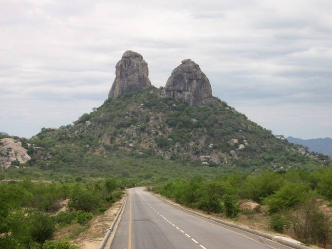
 the
engineer Antonio Vicente Ferreira, baptized the city of Huambo with the name
Nova Lisboa (New Lisbon) and prepared it to be the capital of Angola. However
only the name of the city was changed because of the various schools of opinion
opposed to this city becoming the capital of the country, because of Luandaĺs
more favourable position, at sea. Huambo became the site of a brutal battle
during the bloody civil war between the government and UNITA from independence
until the death of rebel leader Jonas Savimbi. The city was besieged,
extensively damaged, and its civilians fled the city.
the
engineer Antonio Vicente Ferreira, baptized the city of Huambo with the name
Nova Lisboa (New Lisbon) and prepared it to be the capital of Angola. However
only the name of the city was changed because of the various schools of opinion
opposed to this city becoming the capital of the country, because of Luandaĺs
more favourable position, at sea. Huambo became the site of a brutal battle
during the bloody civil war between the government and UNITA from independence
until the death of rebel leader Jonas Savimbi. The city was besieged,
extensively damaged, and its civilians fled the city. the
Benguela cold stream which runs from Antarctica. Its location makes Benguela an
important connection between the country's different regions. Its relief is
varied, dividing the province into three distinctive geographical areas: the
coastline, where the altitude goes from 0 to 500 metres, the centre (500 to 1200
m.) and east, (over 1500 m. average altitude) which is connected to the high
plains of the interior of Angola. Annual rainfall levels range from 600 mm. in
the north to 100 mm. in the south, making a contrast between the regions, from
the fertile Vale do Cavaco to the semi-desert terrain of the southern part of
the province, which blends into the characteristic landscape of the province of
Namibe, which it borders onto. The first landing of Portuguese took place early
as 1600ĺs. They were attracted by an apparent animal richness. After that the
legends of the rich silver and copper mines of the region resulted in the
foundation of S. Filipe de Benguela that would become the basis of penetration
in the island. Lobito was founded in 1843 by the Portuguese. The longest railway
line in Angola, which crosses the country to its borders with Zambia and DR
Congo, departs from its second city, Lobito, which has a deep water port. The
completion of the railroad from Benguela in 1929 made Lobito an important
commercial centre and Angolaĺs chief port, but it declined in the 1970ĺs due to
damage of port facilities during the War of Independence from Portugal. The need
for a harbour and the wonderful conditions gave form to Lobito.
the
Benguela cold stream which runs from Antarctica. Its location makes Benguela an
important connection between the country's different regions. Its relief is
varied, dividing the province into three distinctive geographical areas: the
coastline, where the altitude goes from 0 to 500 metres, the centre (500 to 1200
m.) and east, (over 1500 m. average altitude) which is connected to the high
plains of the interior of Angola. Annual rainfall levels range from 600 mm. in
the north to 100 mm. in the south, making a contrast between the regions, from
the fertile Vale do Cavaco to the semi-desert terrain of the southern part of
the province, which blends into the characteristic landscape of the province of
Namibe, which it borders onto. The first landing of Portuguese took place early
as 1600ĺs. They were attracted by an apparent animal richness. After that the
legends of the rich silver and copper mines of the region resulted in the
foundation of S. Filipe de Benguela that would become the basis of penetration
in the island. Lobito was founded in 1843 by the Portuguese. The longest railway
line in Angola, which crosses the country to its borders with Zambia and DR
Congo, departs from its second city, Lobito, which has a deep water port. The
completion of the railroad from Benguela in 1929 made Lobito an important
commercial centre and Angolaĺs chief port, but it declined in the 1970ĺs due to
damage of port facilities during the War of Independence from Portugal. The need
for a harbour and the wonderful conditions gave form to Lobito.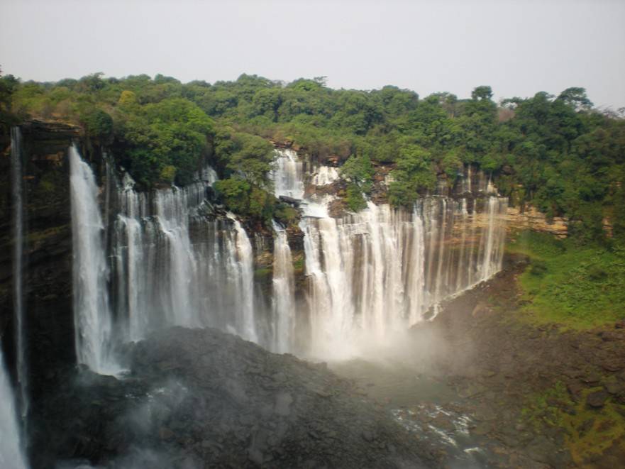 majority of its area. It is famous around the world for a rare plant which is
found here, the Welwitschia Mirabilis. Its capital is in an enormous bay which
deadens the fury of the Atlantic waves, creating some of the finest beaches in
the world. This region was firstly touched in 1485 by a European, Diogo
Cao. It was named of Mocamedes and was the first district to be created in the
South of Angola. In 1840. The organised exploitation of the regionĺs richness
began in 1849 with the arrival of the first settlers coming from Brazil.
majority of its area. It is famous around the world for a rare plant which is
found here, the Welwitschia Mirabilis. Its capital is in an enormous bay which
deadens the fury of the Atlantic waves, creating some of the finest beaches in
the world. This region was firstly touched in 1485 by a European, Diogo
Cao. It was named of Mocamedes and was the first district to be created in the
South of Angola. In 1840. The organised exploitation of the regionĺs richness
began in 1849 with the arrival of the first settlers coming from Brazil.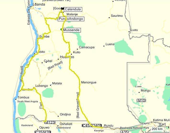